Top Stories
300,000 km of Roman Roads Mapped in Groundbreaking Project
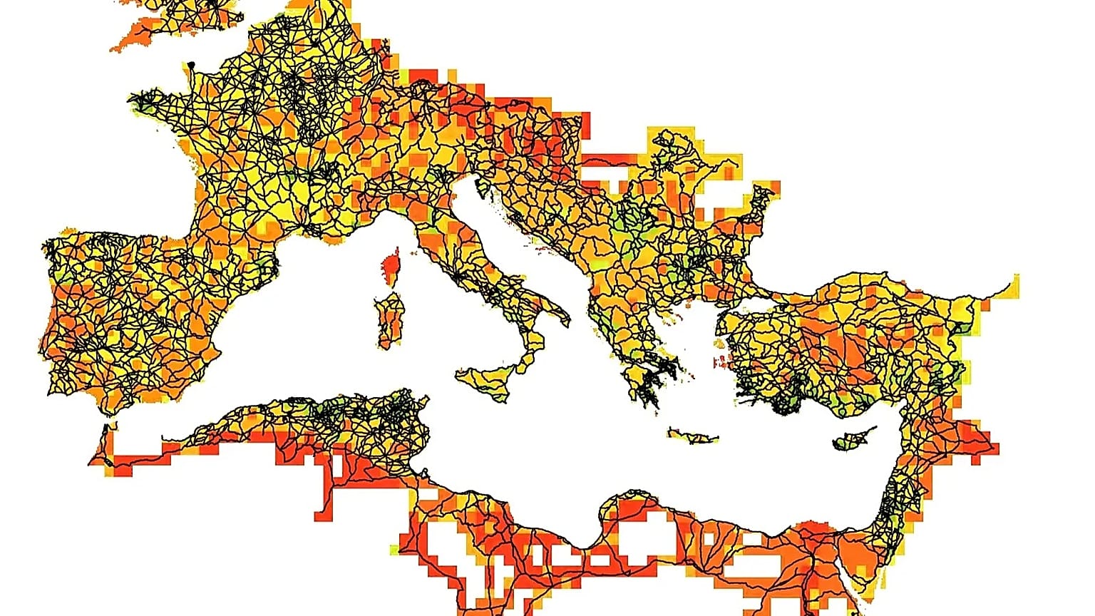
A new digital initiative, Itiner-e, has successfully mapped an astonishing 299,171 kilometres of Roman roads, nearly doubling the previous total of 188,555 km identified by existing resources. This project not only enhances our cartographic understanding of the Roman Empire but also sheds light on the logistical capabilities that allowed Rome to maintain power over centuries.
Revolutionizing Historical Understanding
The research, spearheaded by scholars from the Universitat Autònoma de Barcelona and Denmark’s University of Aarhus, has been published in the journal Scientific Data, part of the Nature group. It represents a comprehensive synthesis of archaeological and historical knowledge, covering the Roman Empire at its zenith, around 150 AD. At that time, the empire spanned nearly 4 million square kilometres, encompassing regions in Europe, North Africa, and the Middle East.
What sets this project apart is the revelation that only 2.737% of the mapped roads have a confirmed spatial location. In contrast, a significant 89.818% of the routes are conjectured, while 7.445% remain hypothetical. This disparity highlights the challenges researchers face in linking historical data to precise geographical layouts.
Methodology Behind the Mapping
The Itiner-e team employed a meticulous three-phase approach to create this digital atlas. Initially, they identified the roads using a combination of archaeological, historical, and epigraphic sources, including excavations and ancient documents like the Antonine Itinerary and the Tabula Peutingeriana. The team also referenced the LIRE database, which contains 8,388 milestones with Latin inscriptions.
In the second phase, the researchers spatially located these roads, comparing their findings with modern and historical topographic maps, aerial photographs—including those from USAF missions in the 1950s—and satellite images. Notably, historical photographs from the Corona programme (1967-1972) played a crucial role in mapping areas now submerged under modern reservoirs.
Finally, each road segment was manually digitized with a spatial resolution ranging from five to 200 metres. This method ensured accuracy by following the natural terrain rather than drawing simplistic straight lines, resulting in 14,769 road segments organized hierarchically.
The project has also produced confidence maps, highlighting regions where data is sparse and guiding future research initiatives aimed at expanding the mapped routes.
A Living Resource for Future Research
Project leaders Pau de Soto, Adam Pažout, and Tom Brughmans emphasized that the extensive dataset generated by the Itiner-e project transforms our understanding of how the Roman road system facilitated the movement of people, goods, ideas, and even disease in antiquity. The high resolution of the map enables new studies on connectivity, transport costs, and administrative control, as well as the evolution of land mobility over millennia.
The interdisciplinary and open-source nature of Itiner-e allows researchers to incorporate new findings while maintaining authorship of their data, making the resource accessible to the public at https://itiner-e.org.
Regions such as the Iberian Peninsula, Greece, North Africa, the Levant, and Asia Minor are among the best documented, thanks to previous projects like Mercator-e and Desert Networks. However, the mapping also reveals significant gaps in current knowledge, with areas of low data representativeness including northern England, Cornwall, and central Anatolia, which are now identified as priorities for future research efforts.
In conclusion, the Itiner-e project stands as the most comprehensive digital map of the Roman road system ever created. With its nearly 300,000 kilometres of documented roads, this initiative not only illustrates the extensive network that facilitated the movement of legions and goods but also underscores how the Romans successfully maintained their empire for centuries.

Black Friday Travel Deals from €159 Spark Irish Holiday Rush

Kilkenny’s Malzards Pub Wins ‘Best Outdoor Space’ Award Now

Urgent Call to Cut Sky-High Driving Costs: Sinn Féin Proposes Measures

Body of Man Found in Co Louth, Foul Play Not Suspected

Nephew of Gerry ‘The Monk’ Hutch Discharged After Aggressive Incident

Galway Volunteers Join Urgent Climate March in Dublin Tomorrow

Inis Oírr and Loughrea Schools Win National Science Film Awards

Minister Unveils €34.5 Million Investment in Groundbreaking Research

Wallabies Aim to Honor Joe Schmidt with Win Against Ireland

Tributes Surge for 9-Year-Old Leon Briody After Cancer Battle

Aimee Osbourne Joins Family for Emotional Tribute to Ozzy

Danny Healy-Rae Considers Complaint After Altercation with Garda

Ireland Enjoys Summer Heat as Hurricane Erin Approaches Atlantic
Hawaii Commemorates 80 Years Since Hiroshima Bombing with Ceremony

Newcastle West Woman Patricia Foley Found Safe After Urgent Search

Fianna Fáil TDs Urgently Consider Maire Geoghegan-Quinn for Presidency

Couple Convicted of Murdering Two-Year-Old Grandson in Wales

Gaza Aid Distribution Tragedy: 20 Killed Amid Ongoing Violence
-
 Top Stories2 months ago
Tributes Surge for 9-Year-Old Leon Briody After Cancer Battle
-
 Entertainment4 months ago
Aimee Osbourne Joins Family for Emotional Tribute to Ozzy
-
 Politics4 months ago
Danny Healy-Rae Considers Complaint After Altercation with Garda
-
 Top Stories3 months ago
Ireland Enjoys Summer Heat as Hurricane Erin Approaches Atlantic
-

 World4 months ago
Hawaii Commemorates 80 Years Since Hiroshima Bombing with Ceremony
-
 Top Stories2 months ago
Newcastle West Woman Patricia Foley Found Safe After Urgent Search
-
 Top Stories4 months ago
Fianna Fáil TDs Urgently Consider Maire Geoghegan-Quinn for Presidency
-
 World4 months ago
Couple Convicted of Murdering Two-Year-Old Grandson in Wales
-
 World4 months ago
Gaza Aid Distribution Tragedy: 20 Killed Amid Ongoing Violence
-

 World4 months ago
Aristocrat Constance Marten and Partner Convicted of Infant Murder
-

 Top Stories3 months ago
Climbing Errigal: A Must-Do Summer Adventure in Donegal
-

 Top Stories3 months ago
Hike Donegal’s Errigal Mountain NOW for Unforgettable Summer Views