Top Stories
Heavy Rain Alert: Spot Flooding Risk Across Ireland This Week
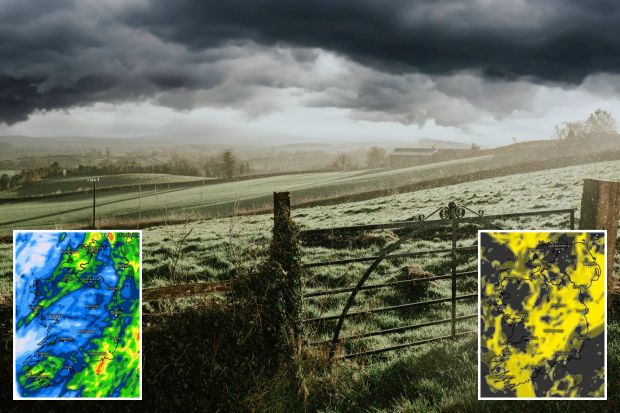
UPDATE: Ireland is bracing for a deluge of heavy rain starting tonight, with Met Eireann warning of potential spot flooding in several regions. The national weather service has pinpointed the worst-hit areas, particularly in Munster and south Leinster, where rain is expected to intensify.
As of this morning, many areas began the day dry and sunny; however, conditions are rapidly changing. Scattered showers are forecasted to spread across the country, intensifying as the day progresses. Gerry Murphy, a forecaster with Met Eireann, stated that while some areas will experience light showers, the worst rain is yet to come.
Tonight, rain will develop in the southwest and quickly spread across much of Munster by nightfall. Heavy showers are set to continue through the night, with warnings of spot flooding in affected areas. Temperatures are expected to drop to between 10C and 13C.
Meteorologist Alan O’Reilly posted on social media, emphasizing that the weather will be “very mixed” in the coming days. Tomorrow morning will see widespread rain, particularly affecting parts of Leinster, where the heaviest downpours are anticipated. Again, the risk of flooding remains high.
Rain is projected to clear slowly eastwards throughout tomorrow afternoon, making way for some sunny spells and scattered showers. Maximum temperatures will be between 14C and 18C.
Looking ahead, Thursday morning is expected to be mostly dry with occasional sunshine, although showers will develop, particularly along the Atlantic coasts later in the day. Temperatures will again reach highs of 15C to 18C.
The weekend forecast remains uncertain, with a low-pressure system threatening further rain on Saturday. Meteorologists anticipate that while initial conditions may be dry, persistent rain could arrive in the west by evening, spreading eastward overnight.
Sunday is projected to be another wet day for many, with temperatures ranging from 15C to 19C.
As weather patterns continue to evolve, residents are urged to stay vigilant and monitor updates from official sources. The potential for significant rainfall and flooding could impact travel and outdoor activities, making it crucial for everyone to prepare accordingly.
Stay tuned for more urgent updates as this situation develops.

Ex-Lover of Robbie Lawlor Released as Dublin Gang Boss Arrested

Zohran Mamdani Wins NYC Mayoral Race, Hope Triumphs Over Despair

Mother Fears More Violence After Drogheda Asylum Centre Fire

Fianna Fáil Election Review Faces Backlash Over Potential Delay

Former British Soldier Arrested in Kenyan Murder Case, Claims “Sex Gone Wrong”

Holly Cairns Calls Out Harris’s ‘Panic’ Immigration Rhetoric

Irish Doctors Use Fizzy Drink as Innovative Cardiac Diagnostic Tool

Shoppers Embrace Thickening Spray for Shine and Volume

High Court Halts Fast-Track Process for Athlone Accommodation Centre

Tributes Surge for 9-Year-Old Leon Briody After Cancer Battle

Aimee Osbourne Joins Family for Emotional Tribute to Ozzy

Danny Healy-Rae Considers Complaint After Altercation with Garda

Ireland Enjoys Summer Heat as Hurricane Erin Approaches Atlantic
Hawaii Commemorates 80 Years Since Hiroshima Bombing with Ceremony

Newcastle West Woman Patricia Foley Found Safe After Urgent Search

Fianna Fáil TDs Urgently Consider Maire Geoghegan-Quinn for Presidency

Gaza Aid Distribution Tragedy: 20 Killed Amid Ongoing Violence

Couple Convicted of Murdering Two-Year-Old Grandson in Wales
-
 Top Stories2 months ago
Tributes Surge for 9-Year-Old Leon Briody After Cancer Battle
-
 Entertainment3 months ago
Aimee Osbourne Joins Family for Emotional Tribute to Ozzy
-
 Politics3 months ago
Danny Healy-Rae Considers Complaint After Altercation with Garda
-
 Top Stories3 months ago
Ireland Enjoys Summer Heat as Hurricane Erin Approaches Atlantic
-

 World4 months ago
Hawaii Commemorates 80 Years Since Hiroshima Bombing with Ceremony
-
 Top Stories2 months ago
Newcastle West Woman Patricia Foley Found Safe After Urgent Search
-
 Top Stories4 months ago
Fianna Fáil TDs Urgently Consider Maire Geoghegan-Quinn for Presidency
-
 World4 months ago
Gaza Aid Distribution Tragedy: 20 Killed Amid Ongoing Violence
-
 World4 months ago
Couple Convicted of Murdering Two-Year-Old Grandson in Wales
-

 World4 months ago
Aristocrat Constance Marten and Partner Convicted of Infant Murder
-

 Top Stories3 months ago
Climbing Errigal: A Must-Do Summer Adventure in Donegal
-

 Top Stories3 months ago
Hike Donegal’s Errigal Mountain NOW for Unforgettable Summer Views