Top Stories
Storm Floris Set to Bring Dangerous Winds and Rain to Ireland
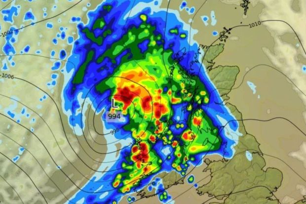
UPDATE: Storm Floris is poised to unleash “unseasonably windy” weather across Ireland, raising fears of power outages and dangerous travel conditions. According to Met Éireann, the storm will begin impacting the country Sunday night and continue into Monday, with severe weather warnings anticipated.
Weather expert Alan O’Reilly from Carlow Weather has detailed that the storm will bring rain and strong gusts of wind, with speeds reaching up to 80 to 90 km/h. As the storm approaches, conditions are expected to deteriorate rapidly, particularly in the northwestern regions.
The nationwide weather advisory is in effect immediately and will last until 1 PM Monday. Travelers should prepare for “dangerous” conditions, which could include fallen trees, debris, and localized flooding. Outdoor events, including the All Together Now festival in Waterford, are likely to face disruptions due to the severe weather.
Forecasts indicate that while Sunday will start with dry and bright weather, rain and gusty winds will sweep across the country by late afternoon. The most intense weather will manifest on Sunday night into Monday, with significant impacts expected in northwestern areas.
Met Éireann forecaster Andrew Doran-Sherlock stated, “Storm Floris will bring a spell of wet and unseasonably windy weather,” emphasizing that the full extent of the storm’s impact remains uncertain until detailed forecasts are available later today.
As residents brace for the storm, there is a crucial window of time today to prepare. Saturday is expected to be relatively calm, allowing people to make necessary arrangements before the severe weather strikes. Highs will range from 16C to 23C across the country, but conditions will shift dramatically in the evening as clouds roll in.
Officials are urging the public to stay updated on local forecasts and heed any warnings issued by meteorological authorities. The potential for wave overtopping along coastal areas poses an additional risk, particularly for those living near the shore.
As Storm Floris approaches, stay tuned for real-time updates and safety advisories to navigate the impending conditions. The storm is expected to clear by Monday, but not without leaving its mark across Ireland.
Residents are encouraged to share their experiences and preparations on social media as the storm unfolds, keeping their communities informed and safe in the face of this urgent weather event.

Cork Man Charged with Rape and Child Exploitation Offenses

New Owners to Preserve Legacy of Denny A’s Pub in Ballingarry

Kieran Cuddihy Withdrawn from Tonight’s Late Late Show Appearance

Stormont Faces Backlash as Mental Health Funding Drops on World Day

Kilkenny’s Lady Lorna Emporium Shapes Irish Fashion Scene

Dublin Councillor Agrees Not to Film Staff of Pepper Finance

Polish Hotel Chain Offers €2,000 and Free Parties to Boost Birth Rate

Kilkenny Businesses From the 2000s: Remember These Iconic Shops?

Munster Hires Clayton McMillan to Revitalize Team Culture NOW

Tributes Surge for 9-Year-Old Leon Briody After Cancer Battle

Aimee Osbourne Joins Family for Emotional Tribute to Ozzy

Danny Healy-Rae Considers Complaint After Altercation with Garda

Ireland Enjoys Summer Heat as Hurricane Erin Approaches Atlantic
Hawaii Commemorates 80 Years Since Hiroshima Bombing with Ceremony

Fianna Fáil TDs Urgently Consider Maire Geoghegan-Quinn for Presidency

Gaza Aid Distribution Tragedy: 20 Killed Amid Ongoing Violence

Couple Convicted of Murdering Two-Year-Old Grandson in Wales

Newcastle West Woman Patricia Foley Found Safe After Urgent Search
-
 Top Stories4 weeks ago
Tributes Surge for 9-Year-Old Leon Briody After Cancer Battle
-
 Entertainment2 months ago
Aimee Osbourne Joins Family for Emotional Tribute to Ozzy
-
 Politics3 months ago
Danny Healy-Rae Considers Complaint After Altercation with Garda
-
 Top Stories2 months ago
Ireland Enjoys Summer Heat as Hurricane Erin Approaches Atlantic
-

 World3 months ago
Hawaii Commemorates 80 Years Since Hiroshima Bombing with Ceremony
-
 Top Stories3 months ago
Fianna Fáil TDs Urgently Consider Maire Geoghegan-Quinn for Presidency
-
 World3 months ago
Gaza Aid Distribution Tragedy: 20 Killed Amid Ongoing Violence
-
 World3 months ago
Couple Convicted of Murdering Two-Year-Old Grandson in Wales
-
 Top Stories4 weeks ago
Newcastle West Woman Patricia Foley Found Safe After Urgent Search
-

 Top Stories2 months ago
Climbing Errigal: A Must-Do Summer Adventure in Donegal
-

 Top Stories2 months ago
Hike Donegal’s Errigal Mountain NOW for Unforgettable Summer Views
-

 World3 months ago
Aristocrat Constance Marten and Partner Convicted of Infant Murder