Science
Researchers Unveil Extensive Mapping of 300,000 km of Roman Roads
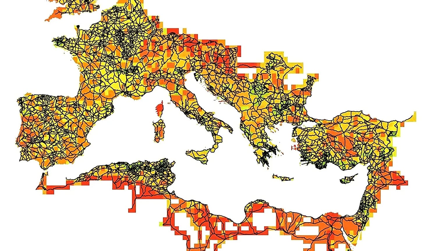
A groundbreaking digital project has successfully mapped approximately 300,000 kilometres of Roman roads, nearly doubling the previously documented length. The Itiner-e initiative, led by researchers from the Universitat Autònoma de Barcelona and Denmark’s University of Aarhus, aims to enhance our understanding of the Roman Empire’s infrastructure and its implications for governance and connectivity.
Published in the journal Scientific Data, this comprehensive dataset represents a synthesis of historical and archaeological research spanning centuries. The mapping project covers the Roman Empire at its peak around 150 AD, encompassing almost 4 million km² across Europe, North Africa, and the Middle East.
What distinguishes this project is the revelation that only 2.737% of the mapped routes have a certified spatial location. In contrast, 89.818% are conjectured, and 7.445% are hypothetical. This significant discrepancy highlights the challenges of accurately detailing ancient road networks.
Methodology Behind the Mapping Project
The Itiner-e team employed a three-phase methodology to construct this digital atlas. Initially, they identified roads using a combination of archaeological, historical, and epigraphic sources, including excavations, historical documents such as the Antonine Itinerary and the Tabula Peutingeriana, and milestones known as Roman kilometre markers. They also utilized the LIRE database, which features 8,388 milestones bearing Latin inscriptions.
Next, the researchers spatially located these roads by cross-referencing findings with modern and historical topographic maps, aerial photographs—including missions conducted by the USAF in the 1950s—and satellite imagery from the Corona programme (1967-1972). The latter proved crucial for regions now submerged beneath contemporary reservoirs. Finally, the team manually digitised each road segment, achieving a spatial resolution ranging from five to 200 metres, ensuring the representation followed the natural landscape rather than simplistic straight lines.
The outcome is a detailed illustration comprising 14,769 road segments, meticulously organized into a two-level hierarchy. The project also produced confidence maps to highlight areas lacking data, guiding future research efforts.
Impact and Future Prospects
Project leaders Pau de Soto, Adam Pažout, and Tom Brughmans emphasized the transformative potential of the dataset for understanding how the Roman road network facilitated the movement of people, goods, and ideas in antiquity. The high-resolution map opens avenues for new computational studies on connectivity, transport costs, and administrative control, as well as the historical evolution of land mobility.
The Itiner-e project embodies an interdisciplinary, collaborative, and open-source approach, allowing researchers to incorporate new findings while retaining ownership of their contributions. The dataset is accessible to the general public at https://itiner-e.org. Among the best-documented regions are the Iberian Peninsula, Greece, North Africa, the Levant, and Asia Minor, thanks to prior initiatives like Mercator-e and Desert Networks.
Despite its comprehensiveness, the map reveals significant gaps in existing knowledge. Areas with low data representation include northern England, Cornwall, the middle and upper Danube, Tuscany, Corsica, and central Anatolia. These regions are prioritized for future research campaigns, along with North African deserts and mountainous terrains, which present considerable documentation challenges.
The Itiner-e project stands as the most extensive digital map of the Roman road system ever created. With its almost 300,000 kilometres of documented routes, it sheds light on how the Roman Empire effectively moved its legions, facilitated trade, and maintained power for centuries, offering insights that resonate with contemporary discussions about infrastructure and governance.

Mother Reveals Daughter’s Meningitis Seizure After Night Out

Major Oil Spill Disrupts Traffic in Donegal on March 16, 2026

Discovering Literature: The Joys of Rejoining a Public Library

Ted Season 2 Announced: Release Date & Trailer Updates Revealed

Research Ireland and UKRI Forge New Collaboration Agreement

David McGoldrick’s Impressive Scoring Streak Sparks World Cup Talk

Plane Crash Claims Lives of Publishing Heir, Pregnant Wife, and Pilot

Oscars Snub Brigitte Bardot Sparks Controversy Over In Memoriam

Meta Plans Major Layoffs to Offset Rising AI Investment Costs

Tributes Surge for 9-Year-Old Leon Briody After Cancer Battle

Aimee Osbourne Joins Family for Emotional Tribute to Ozzy

Danny Healy-Rae Considers Complaint After Altercation with Garda
Hawaii Commemorates 80 Years Since Hiroshima Bombing with Ceremony

Ireland Enjoys Summer Heat as Hurricane Erin Approaches Atlantic

Couple Convicted of Murdering Two-Year-Old Grandson in Wales

Gaza Aid Distribution Tragedy: 20 Killed Amid Ongoing Violence

Newcastle West Woman Patricia Foley Found Safe After Urgent Search

Fianna Fáil TDs Urgently Consider Maire Geoghegan-Quinn for Presidency
-
 Top Stories11 months ago
Tributes Surge for 9-Year-Old Leon Briody After Cancer Battle
-
 Entertainment1 year ago
Aimee Osbourne Joins Family for Emotional Tribute to Ozzy
-
 Politics1 year ago
Danny Healy-Rae Considers Complaint After Altercation with Garda
-

 World1 year ago
Hawaii Commemorates 80 Years Since Hiroshima Bombing with Ceremony
-
 Top Stories12 months ago
Ireland Enjoys Summer Heat as Hurricane Erin Approaches Atlantic
-
 World1 year ago
Couple Convicted of Murdering Two-Year-Old Grandson in Wales
-
 World1 year ago
Gaza Aid Distribution Tragedy: 20 Killed Amid Ongoing Violence
-
 Top Stories11 months ago
Newcastle West Woman Patricia Foley Found Safe After Urgent Search
-
 Top Stories1 year ago
Fianna Fáil TDs Urgently Consider Maire Geoghegan-Quinn for Presidency
-

 World1 year ago
Aristocrat Constance Marten and Partner Convicted of Infant Murder
-

 Top Stories12 months ago
Climbing Errigal: A Must-Do Summer Adventure in Donegal
-

 Top Stories12 months ago
Hike Donegal’s Errigal Mountain NOW for Unforgettable Summer Views